Mapping of grass-leaved goldenrod (BSc thesis)
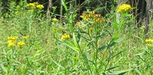
The renaturation of the Thur between Eggrank and the mouth of the Thur created the largest floodplain in the Swiss midlands. In the course of the measures, a large number of very different habitats were created in a very confined space (Naturzentrum Thurauen, Amt für Landschaft und Natur, Kanton Zürich). In addition, neophytes also occur in the Thurauen, such as the grass-leaved goldenrod (Solidago graminifolia), about which very little is known so far. The spread potential of the grass-leaved goldenrod is currently not considered to be problematic for the floodplain conservation area. However, it would be of great interest to learn more about the locations and the degree of cover of this plant in the Thur floodplains.
Task
As part of a bachelor's thesis, the sites of grass-leaved goldenrod (Solidago graminifolia) were to be mapped for the first time in July / August 2014 in the Thurauen.
The mapping was carried out by Andrea Weber at the Department of Environmental Systems Science at ETH Zurich as part of a Bachelor's thesis (2014/2015), in collaboration with the Thurauen Nature Centre and Andrea De Micheli, coordinator for neophyte control in the Thurauen.
Mapping
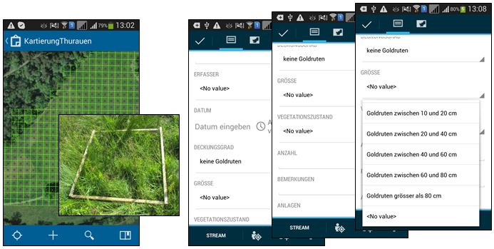
For the mapping of the known areas, two GIS datasets were modelled in ArcGIS Desktop and made available via ArcGIS Online on the Collector for ArcGIS app.
The first dataset contained a regular polygonal grid of 10 x 10 m. This size was necessary due to GPS accuracy. This size was necessary due to the GPS accuracy of only approx. 3 m. This guaranteed that mapping was done within the respective quadrant. The second data set is a point data set and represents the centre of each 10 x 10 m area.

Each grid area can be assigned the property "no goldenrod", "few goldenrods" or "many goldenrods". In addition, the following properties can be recorded: Date, degree of cover, size of the plants and vegetation condition. In addition, it is possible to add a comment and to attach attachments to the data record, such as photos or documents. The properties mentioned were not determined over the entire area of a grid, but representatively within a 1 x 1 m frame within an area.
For the mapping of new discoveries, a point data set was created with the following attributes: Number, Density, Areas, Remarks. The location of the new discoveries was defined as a point with the help of the GPS and a high-resolution aerial photograph.
Results
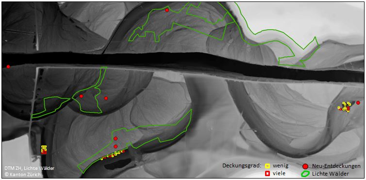
The following two figures show the results of the mapping work. The first figure shows an overview of the mapping results, backed by a digital terrain model (resolution: 0.5 m) and overlaid with a data set showing the "light forests".
The high-resolution terrain model clearly shows the former course of the river Thur. The known sites of grass-leaved goldenrod are all located in the area of the former river course, where the groundwater today runs very close to the surface. These sites are therefore rather moist, which is an advantage for the grass-leaved goldenrod.
Furthermore, the figure shows that there are some new discoveries in the Thurauen area. It is striking that the new discoveries are often located near or within a sparse forest.
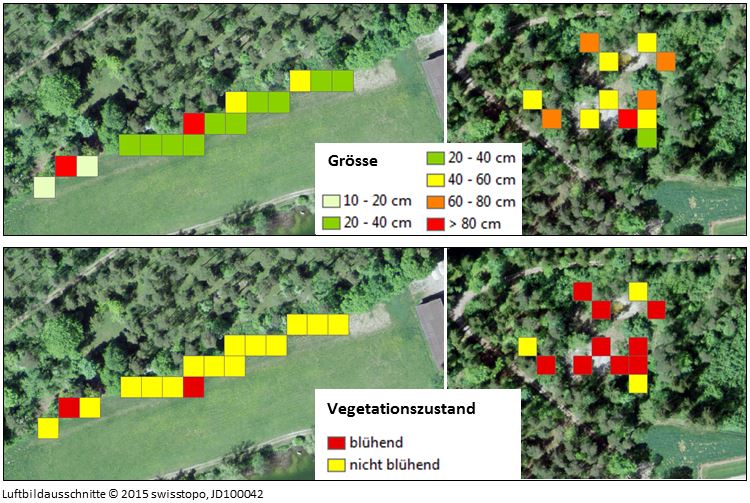
The second figure shows the size and vegetation condition of grass-leaved goldenrod at the time of recording for two known sites.
The first area has predominantly smaller, "non-flowering" plants. This can be explained by the fact that the area had already been mown once in spring. In the second area, there are rather larger plants with a "flowering" state. The plants are plucked out here.
The bachelor thesis has shown that the grass-leaved goldenrod has a certain invasion potential, which has probably not yet been exhausted. As the mapping in the Thurauen was carried out for the first time, it is not yet possible to make any statements on invasiveness. However, it is advisable to regularly observe and map the sites and, as far as possible, to control them by plucking.


